
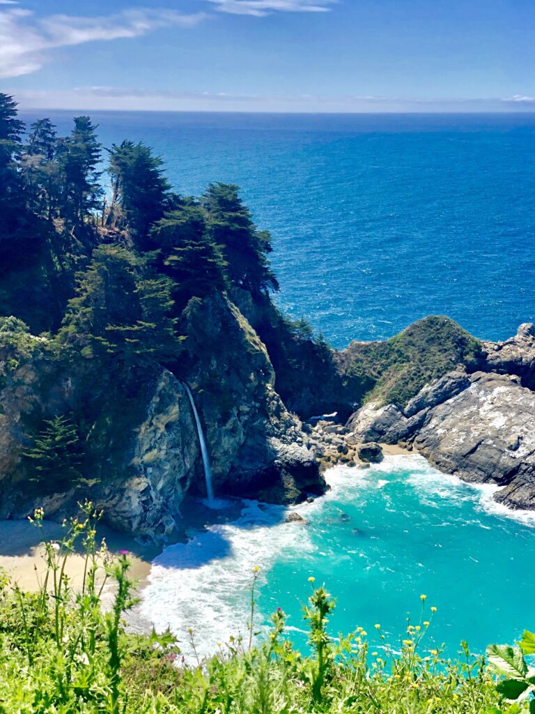
McWay Falls is one of the most iconic waterfalls in California. Located along Big Sur’s spectacular coastline, this 80-foot waterfall cascades from a rocky cliff into a secluded coastal cove. The turquoise waters, rugged cliffs, and surrounding greenery create a breathtaking landscape.
What makes McWay Falls especially remarkable is its reputation as one of the world’s rare tidefalls. A tidefall is a waterfall that empties directly into the ocean. This unusual natural feature makes McWay Falls one of Big Sur’s most recognizable scenic attractions.
However, access to the waterfall and its viewing areas may be restricted. Visitors should always check current park conditions before traveling.
Where Is McWay Falls Located?
McWay Falls is located within Julia Pfeiffer Burns State Park along California Highway 1 in Monterey County. The park sits approximately 37 miles south of Carmel-by-the-Sea and 12 miles south of the Big Sur village area.
The waterfall lies where the Santa Lucia Mountains descend toward the Pacific Ocean. Here, steep coastal cliffs surround McWay Cove, a small beach with striking blue-green water.
Additionally, the surrounding landscape belongs to one of California’s most scenic coastal regions. Its combination of mountains, ocean, and waterfalls creates a remarkable natural setting.
Why Is McWay Falls Considered a Tidefall?
McWay Falls is often described as a tidefall, a rare type of waterfall that flows directly into the ocean.
Historically, McWay Falls dropped straight from the coastal cliffs into the Pacific Ocean. However, a massive landslide changed the surrounding shoreline. Over time, ocean currents moved sediment into McWay Cove and created the sandy beach visible today.
As a result, the waterfall now typically lands on the beach rather than directly in the ocean. During high tides, however, waves can reach the base of the falls.
This unusual combination of a coastal waterfall, sandy cove, and turquoise ocean makes McWay Falls one of California’s most distinctive natural landmarks.
Where Does the Water at McWay Falls Come From?
The waterfall originates from McWay Creek, a year-round stream fed by springs and seasonal rainfall in the Santa Lucia Mountains.
As the creek flows through McWay Canyon, it travels across forested slopes and rugged terrain. Eventually, the water reaches the coastal cliffs and plunges approximately 80 feet into McWay Cove.
McWay Falls flows throughout the year. However, its volume typically increases during winter and spring when rainfall is more abundant.
How to Get to McWay Falls
McWay Falls is located along California Highway 1 inside Julia Pfeiffer Burns State Park.
Travelers approaching from the north can follow Highway 1 south from Carmel-by-the-Sea. Meanwhile, visitors traveling from the south can approach from San Simeon or Cambria when the highway is open.
The park includes a designated day-use parking area. However, parking availability and access to viewing areas can change because of weather, maintenance, or safety restrictions.
Before traveling, check highway conditions through Caltrans QuickMap and review the latest notices from California State Parks.
Is McWay Falls Open?
McWay Falls is a natural, year-round waterfall. However, access to the surrounding park and designated viewing areas may be limited or temporarily closed.
Storm damage, trail maintenance, landslides, and other safety concerns can affect access to the McWay Falls Overlook Trail.
Consequently, visitors should not assume the overlook is accessible simply because Highway 1 is open.
For the latest information, consult the official Julia Pfeiffer Burns State Park website before planning a visit.
Can You Access McWay Falls?
No. Visitors cannot access the base of McWay Falls or the beach at McWay Cove.
California State Parks prohibits entry to the beach and surrounding restricted cliff areas. These restrictions protect both visitors and the fragile coastal environment.
Furthermore, the terrain includes unstable slopes, loose rocks, and steep drop-offs. Attempting to reach the beach can result in serious injury.
McWay Falls is intended to be appreciated from authorized viewing areas rather than from the beach below.
Where Can You View McWay Falls?
The McWay Falls Overlook Trail is the park’s established viewing route. When open, this short trail provides beautiful views of the waterfall and surrounding coastline.
The trail extends approximately half a mile round trip. It passes beneath Highway 1 before following the coastal cliffs toward a designated overlook.
From the viewing area, visitors can admire the waterfall, secluded beach, and Pacific Ocean.
However, trail access can change due to erosion, maintenance, and other safety concerns. Therefore, visitors should confirm that the overlook is open before arriving.
Always remain on authorized trails and respect posted closures. Additionally, avoid unstable cliff edges and restricted areas.
Is McWay Falls Worth Visiting?
Absolutely. McWay Falls is one of Big Sur’s most extraordinary natural attractions.
Few places along California’s coastline combine a year-round waterfall, secluded beach, and dramatic ocean scenery. Its reputation as a rare tidefall makes it even more remarkable.
Moreover, the surrounding landscape offers an exceptional example of Big Sur’s rugged coastal beauty.
However, the experience depends on current trail conditions and available viewing areas. Visitors should confirm access before making a dedicated trip.
Whether admired from an open designated overlook or appreciated as part of Big Sur’s natural heritage, McWay Falls remains an iconic symbol of California’s Central Coast.
For more coastal scenery, explore our guides to Big Sur’s best attractions, state parks, and scenic Highway 1 destinations.